No chains required coming into Wrightwood. Chains are required past Mtn High to grassy hollow on hwy 2. Today will be busy so start your trip early. It should be a great day to come play in the snow. Make sure to always carry cables or chains if you have them. Stop by Mtn Hardware to get your Free snow play map. Drive Carefully. Melissa
Good Morning. It is currently snowing here. Chains are required at this time. My suggestion would be to not come up to the mountain until Friday as the weather service says it will still be snowing tomorrow. I will post Friday morning with the current conditions. Have a Happy Thanksgiving.
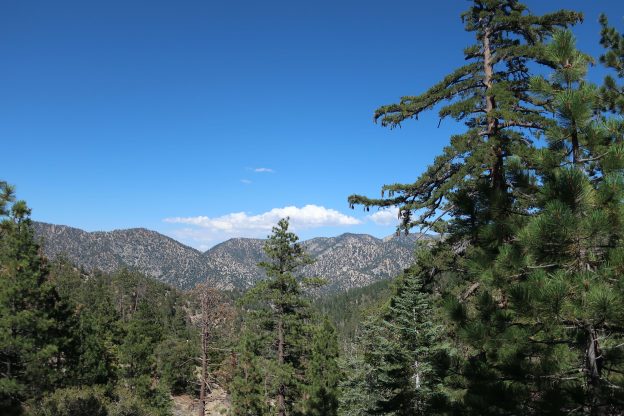
This trip samples the beautiful middle high-country of the San Gabriel Mountains from Chilao Flat to Buckhorn Campground. This is an area replete with grand views of front country peaks, high country forested slopes, finished off by hiking along a shaded stream reminiscent of the High Sierra.
Distance, one-way = 13 miles
Elevation gain = 1,350′ Starting elevation = 5,220′ at Chilao trailhead, eventually reaching a high point of 7,018′ at Cloudburst Summit. The end of the hike culminates with a little climb up to 6,570′.
This one-way trip is best done as a car shuttle, getting a ride to the Upper Chilao loop road adjacent to Newcomb’s Ranch on Highway 2. Leave the second car at the Burkhart Trailhead in Buckhorn Campground. Bring at least two to three liters of water per person.
Maps – I took Tom Harrison’s Angeles Front Country and High Country maps. Mileages and elevations are taken from these two maps.
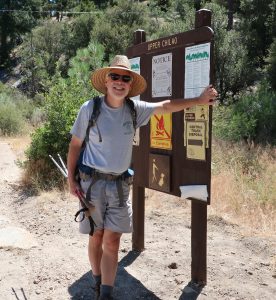
A photo my wife took of me at the start of the hike in Chilao.
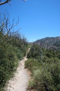
On a warm August morning I started out at the sun-baked trailhead on the Upper Chilao Road. Sage brush and Yerba Santa dominate the sandy soil. The sweet vanilla of Jeffrey pines wafts through the warm pools of dry air. The trailhead is at a spot where you can head either down the Silver Moccasin Trail to Little Pines Campground in lower Chilao or…. up toward Horse Flats and Bandido Campgrounds heading toward Three Points. I took the latter. The trail quickly climbs, switchbacking through Manzanita, White Thorn chaparral (Buckbrush) and more sunlit glades of the shiny, ragged Yerba Santa. Poodle Dog bush also makes its’ presence and I keep way clear of it! I stop where scrub oaks provide a bit of shade and begin drinking from my two Nalgene bottles, already wondering if a third liter wouldn’t have been a good idea. Chilao is for the most part gently sloping terrain with dry grassy flats and groves of Jeffrey and Coulter pine set next to scenic clearings. It’s Thursday and I’ve only encountered one hiker who’s sporting a bug net over his head. Peace and quiet finds me under a bright blue sky which brings on the gift of dry, gently moving air. Bandido Campground is quiet and vacant, it’s corrals empty under more groves of pine. Soon I pass by camper less Angeles Crest Camp, the trail then cresting over a dry ridge of water tanks. From here the sun-scorched trail runs parallel and just below the Santa Clara Divide Road to Three Points. The burned-off remnants of oaks and chaparral stand as sentinels of the Station Fire, now 10 years past. Amazing how fast time flies.
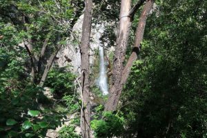
Looking south and west across the Chilao high country. The peaks along the skyline are, left to right, Occidental, San Gabriel, Lawlor and Strawberry.
This is a terrain, where in my case, is something to just be gotten through in the sharp, hard sunlight.
Soon I’m at Three Points and have finished about three miles. Here the Pacific Crest Trail (PCT) ties in with my route just before crossing Highway 2. Almost immediately I’m in the welcome shade of Incense Cedar. After traversing the hot, burnt-off chaparral, it’s like heaven traversing the north facing timbered slopes and drainages for the next five miles to Cloudburst Summit. I pass by Camp Cumorah Crest which also lies quiet and unoccupied by any
Much of Chilao is a land of gently sloping grasslands and easy hiking.
campers, just like the ridge top, sunburnt Camp Eaton. On goes the trail, an old dirt road that’s become single track, pocked by about four springs seeping out from the sides of Mt. Waterman. Thick tangles of scarlet monkey flower and willows compete for the moist sand and soil.
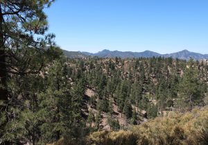
Sunlit and scorched. This section of the Silver Moccasin still appears bleak ten years after the Station Fire burned through.
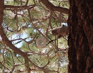
Eventually, the trail crosses the highway, again, taking me past quiet Camp Glenwood and passing more verdant greenery in a deeply wooded canyon. My route follows the old phone line that used to make its’ way to Buckhorn and even onto the now defunct Kratka Ridge ski hill. Eventually, an old dry stack wall of stones catches my eye. I’m near the site of long-gone Camp Pajarito and I’m poking around what appears to be a cabin site when my eyes catch a split ceramic insulator still attached to a big pine. Old times. This type of phone line insulator is still used still in a crank telephone system that travels from tree to tree in the front country’s Big Santa Anita Canyon. My mind’s pulled back to a time long before the Angeles Crest Highway would be built through the San Gabriels. So, on I go, climbing up and up on a remnant road back up to the highway. Again, the trail crosses and it’s a bit more of an uphill pull to the highest part of the trip, 7,018′ high Cloudburst Summit. One of the great things about doing this hike midweek is the lack of cars and motorcycles on Highway 2. It’s just so peacefully quiet, entirely devoid of modern noise. I look both ways before crossing the
highway for one last time before descending the 2.6
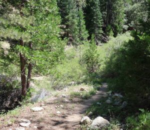
Incense cedar and white fir grace the north slopes of Mt. Waterman as the trail makes its’ way toward Cloudburst Summit. This refreshingly green scene is in stark contrast to the area of the hike just prior to Three Points!
miles into Cooper Canyon.
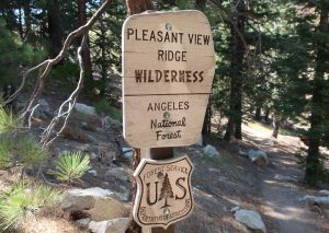
From here, the trail drops down through the pines in tight little switchbacks, passing into the Pleasant View Wilderness. Almost out of water, I’m looking forward to filtering some water from the stream somewhere below Cooper Canyon Campground. An expansive view opens up northward to Pleasant View Ridge. True to its’
name, it really is a pleasant view to take in.
A split ceramic phone insulator from days gone past. This type of insulator once held a single, uninsulated phone line when magneto (crank) phones were used throughout the mountains. This insulator pre-dates construction of Highway 2.
The PCT / Silver Moccasin trail now crosses the little fire road which heads down to the campground. Staying high on the slope, the trail traverses way out and around airy, open stands of pine and incense cedar. I walk into Cooper Canyon Campground, quiet and well-maintained with its’ old Klamath style cook stoves lined up neatly above the stream. The peace of the place settles into me. Resting my tired feet, I have a little snack and start thinking about water once, again… The sun angles a bit more to the west and it’s time to go. The trail continues for another 1.1 miles downstream to the Burkhart Trail. The gurgling creek meanders under thickets of willow, white alder and buckbrush. Tranquil pools in the gold, heartbreaking late light begin to appear, as do lucrative little camping spots that dot the creek. Finally, at the stream crossing, I put down my burden and get out the filter and the empty water bottles. Hunkered down amongst the smoothly sculpted boulders I find a good spot to sit and top off the water bottles in one of the last little pools of light. Little bunches of columbine are growing in the damp sand. Giant incense cedars are interspersed by tall alders with ancient furrowed bark, giving the place a primeval feel. So, I drink deeply til I can hold no more. Then I went on for the final piece of the hike.
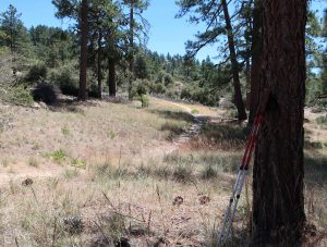
Pleasant View Ridge Wilderness boundary. You’ll pass this sign just a short distance down from Cloudburst Summit as you head toward Cooper Canyon
Eventually I made my way up the steeply pitched Burkhart Trail for the last 1.4 miles to Buckhorn. This was a great day with lots of variety. Amazingly I only saw two people the entire way. Good times in the high country.
by Chris Kasten
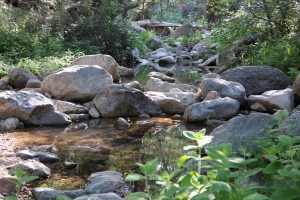
Quiet stream about a mile down from Cooper Canyon. Near here is where the Burkhart Trail climbs back up to Buckhorn Campground.
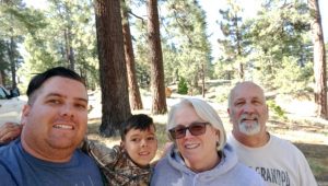
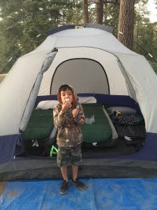
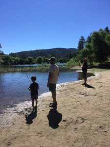
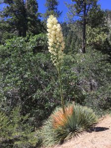
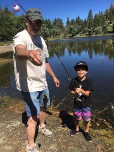
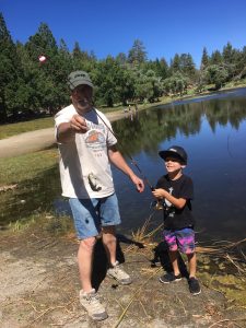
This is Teri, last weekend I went camping at Table Mountain with my family. It was amazing, trees everywhere. The temperature was at least 20 degrees cooler than off the hill. We took our grandson fishing for the first time at Jackson Lake. He caught a small catfish!! We also saw some beautiful yucca while hiking on Jackson Lake trail. The sunsets were gorgeous!!
If you’re looking for something to do come on up to Wrightwood!!
Stop by Mountain Hardware we’d love to see you! #wrightwood #jacksonlake #fishing #hiking #camping #sunsets #family #mtnhardware #summertime
Good Times in the Big Santa Anita Canyon – Hiking Chantry Flats to Sturtevant Falls
Trip distance, one way = 1.8 miles
Elevation loss / gain = 440′ of loss in the first 3/4 of a mile with 250′ of gain in the next mile to the base of Sturtevant Falls.
Rating: An easy, family friendly hike. Great place to walk dogs, too!
Although the drive to the trailhead takes about an hour and a half from Wrightwood, it’s well worth seeing this “front country” of the San Gabriels, so completely unlike the high-country that we’re so used to up here around the Big Pines and Grassy Hollow recreation areas.
Just this last week we took a little day hike up toward Sturtevant Falls in the Big Santa Anita above Arcadia. A beautiful Spring day, the sky was a deep blue and a gentle, refreshing sea breeze enveloped us as we descended into the canyon bottom. Little gusts of wind swirled through canopies of young maple leaves. Although the descent is a gated, paved fire road in the beginning, there are expansive vistas out toward towering Clamshell Ridge, its’ slopes clad in endless shades of green chaparral deeply furrowed by steep, narrow side canyons. The sound of the stream below continued to grow as we dropped down San Olene Canyon. Once at the bottom, we crossed the little green foot bridge at Roberts’ Camp. Once a bustling trail resort in the early 20th century during the Great Hiking Era, Roberts’ was situated at the confluence of the Winter Creek and Big Santa Anita Canyon. Although the buildings are long-gone, the spot is still an important trail junction for hikers making their way into the mountains. See John W. Robinson’s, “The San Gabriels” for thorough and colorful history of the trail resorts throughout the “front country” of the San Gabriel mountains.
From here, we headed upstream toward Sturtevant Falls on the Gabrielino National Recreation Trail. We were on our way to the little family cabin in the Fern Lodge area and then onto the falls. Passing under the overarching canopies of mammoth canyon live oaks, laurel bay, big-leaf canyon maple and white alder, we made our way through the translucent greenish, cool light of the canyon. The stream gurgled and rushed about the smooth, rounded boulders, alternating between little rapids and still tranquil pools. The canyon wrens serenaded us with their laughing calls from little rocky nooks, sweetly broken into descending notes. At one point, we stopped to pick a little miner’s lettuce. Thelma tried a little, too, and was surprised by how good this mountain delicacy of the spring time truly was!
Soon we crossed the little plank bridge over to the little cluster of cabins and made ourselves at home in the little (360 square feet) cabin that was built way back in 1916. The history of these 80 cabins in the Big Santa Anita Canyon is a story in itself. Back between 1912 to the early 1920’s, building materials were packed by mule from Sierra Madre into the canyon where upwards of 220 cabins were erected on just about every little natural perch we can imagine. Every cabin is owned by those canyon dwellers who are willing hike into their “labor of love”. My folks bought our place 35 years ago and it still feels like yesterday. After having lunch out on the creek side porch, Joanie and I set up the croquet court for a quick game on one of the level spots to be found between Chantry and the falls. As always, when you’re having fun, the time flew by fast and we were soon hiking back out and then, up, up, up the hill at the end and onto our car. I was thinking of pizza as Joanie, Thelma and I trudged on. Sarah, of course, left us in the dust and not to be seen, again, until we were nearly back up at the top! Once down in Sierra Madre, we filled up on big slices of pizza before the drive back home. Good times.
Hiking up Mt. Baden-Powell to check out the trail conditions.
Today, despite the incoming wind, drizzle and snow, I took a little day hike up the PCT to get a look at the trail conditions.
Left the Vincent Gulch Divide (Vincent Gap) and headed up the PCT through the damp red soil and onto the thickly forested northeast facing slope of Mt. Baden-Powell. Masses of clouds were gusting by and into the desert.
The bulk of the route up to the summit is snow-free. Hiking up past Lamel Spring and the camping flats alongside the trail was easy hiking. I encountered some PCT through hikers heading uphill in the fog and drizzle. Apparently at least one, if not two, turned back around and I never saw them, again. Maybe they caught rides back to Wrightwood to wait out the impending storm.
I hiked on to the area where the switchbacks begin to tighten up in a forest of lodgepole pines. Banks of snow covered the trail, creating an alternating pattern of clear damp trail along with tracks worn into and over the mounds of slick, hard-packed snow.
Eventually, I was contouring atop perpetual snowfields at an elevation of approx. 8,800′. The visibility had decreased down to a couple of hundred feet and the switchbacks were no longer clearly defined. The snowpack was textured in some spots and occasionally glazed. The snow was too packed to kick into. Since I had no micro spikes or any other types of traction, it was time to turn around and call it a day. It was 11:30 a.m. when I started heading back down. Chris Kasten
Beautiful day at Jackson lake in the Wrightwood/Big Pines area caught a couple fish and enjoyed the tranquill peace of the mountain. No place I would rather be.
Come up the lake is full the 1st time in many years.
Gary
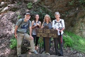
We met TinMan from Syracuse New York. He is hiking the Pct with the help of Warrior Expeditions. This non profit organization helps war combat veterans transition back into normal life by hiking out the war. Happy hiking TinMan from all of us at Mtn Hardware. #warriorexpeditions #mtnhardware #wrightwood #hiking